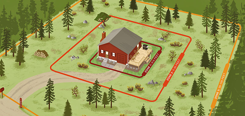
We arrive, we walk the property with you, and we look at it the way fire will approach it.
That takes somewhere between forty-five minutes and a couple of hours depending on the size of the parcel and how much ground there is to cover. You're welcome to walk it with us — most people do, and it's the most useful part for both sides. You learn what we're seeing; we learn what matters to you.
Then you get a plan, in writing, with a firm number.
A lot of what determines whether a house survives isn't visible from where you park.
We use drones, photography and mapping to build a complete picture — roof condition and what's collecting in the valleys, vent locations and what's screening them, deck construction and what's underneath, fuel continuity across the whole parcel, slope and aspect, and whether an engine could actually reach you and turn around at the top.
On larger or steeper properties the aerial view routinely shows things nobody standing on the ground would catch — a continuous canopy running up a drainage toward the house, or a neighbor's untreated stand that changes how fire would arrive.
That photography does a second job. It becomes your before documentation, which matters later.
The structure itself. Roof and gutters, vents and how they're screened, what's stored under the deck, siding at ground level, windows, and where fencing meets the wall.
The first five feet. What's growing or stacked against the house. This is where most homes are actually lost, and it's the cheapest thing on any property to put right.
Five to a hundred feet and beyond. Crown spacing, ladder fuels, dead and downed material, and how far the treated area needs to extend downslope.
Slope, aspect and siting. Where the house sits relative to the terrain and the prevailing wind. A house at the top of a drainage is at the top of a chimney.
Access. Driveway width, overhead clearance, and whether there's a turnaround at the top. This is compliance in several counties, and it's the thing that fails properties at inspection.
What's already been done. If you've mitigated before, we'll tell you honestly whether it's holding up or whether growth has closed the gaps you opened.
A written plan built for your property. Not a checklist with your address on it. Colorado's landscapes vary and so do properties — the plan accounts for your slope, your stand type, your access, and your priorities.
A firm number. In writing, at no charge, before you decide anything.
Prioritisation. What actually matters, what can wait, and what we'd do first if it were our house. Sometimes that answer is clean your gutters and screen your vents, then call us next year. We'd rather tell you that than sell you a project you don't need.
Funding guidance. Whether a state tax credit or a cost-share grant applies to your situation, and — importantly — whether you should apply before we do any work. Several programs disqualify you if you start first.
The photography and mapping, which becomes your before documentation.
Colorado Wildfire Mitigation is on Jefferson County's list of Certified Wildfire Mitigation Specialists approved to perform defensible space inspections. When the county issues a defensible space permit, that list is what the homeowner receives.
That matters here for a specific reason. When we assess a property in Jeffco, we're reading it against the standard we apply ourselves as inspectors — not guessing at somebody else's interpretation of it.
And if your project needs a permit, one company can handle the plan, the work, and the inspection that signs it off, rather than you coordinating a contractor and a separate inspector around a Certificate of Occupancy deadline.
A lot of assessments start with a letter — a premium increase, a request for photos, or a non-renewal notice.
Since HB25-1182 took effect in July 2026, insurers using wildfire risk models have to disclose your wildfire risk score, account for documented mitigation, and give you a route to appeal. What that means practically is that the documentation is worth as much as the work.
If that's why you're calling, say so. We'll structure the assessment around what your carrier is likely to want to see, and the packet you get at the end is built for exactly that conversation.
If you book work, there's a second visit before anything gets cut.
We do a preliminary walkthrough: more photographs, trees marked for removal, and safety hazards flagged. Nothing gets cut that you haven't seen marked. If you disagree with a mark, that's the moment to say so — not afterwards.
We work with absentee and out-of-state owners regularly. If you can't be there, we'll walk it, document it thoroughly, and talk you through it by phone with the photography in front of you.
It's better if you can attend, because a lot of the plan depends on your preferences — how you want Zone 1 finished, which trees matter to you. But it isn't a requirement.
Is it really free?
Yes. No charge for the visit, the plan, or the number. We don't ask for anything up front and we don't send anyone away with an invoice for a walkthrough.
How long does it take?
Usually forty-five minutes to a couple of hours depending on the size of the property.
Do I need to be there?
It helps, and most people prefer to be, but it isn't required. We work with absentee owners regularly.
Will you pressure me to book?
No. You get a written plan and a number, and you decide in your own time. If the honest answer is that you don't need much, we'll say that.
What if I've already had someone else assess it?
Bring us their report. A second read costs you nothing, and we'll tell you plainly if we agree with it.
Is this the same as a Jefferson County defensible space inspection?
No. This is a free assessment for planning work. A county inspection is a formal verification tied to a permit. We do both, and we'll tell you during the assessment if your project needs the second one.
How soon can you come out?
Assessments are usually quicker to schedule than the work itself. Scheduling tightens as fire season approaches — winter is often the fastest time to get on the calendar, and the ground conditions are better for the work that follows.
Where we do this
Free wildfire risk assessments across the Colorado foothills — Evergreen, Conifer, Bailey, Golden, Woodland Park and Nederland — and throughout Jefferson, Park, Teller, Boulder, Larimer, Douglas and El Paso counties.
The questions we get asked on nearly every property walk — cost, funding, and what it means for your insurance.
Wood production is a complex and vital industry that involves the cultivation, harvesting, processing, and utilization of wood for various purposes. It serves as a cornerstone in numerous sectors.
%20(1).png)
